THE SALTSTRAUM
Norwegian version of this page.
Saltstraumen (literally the salt sea current) is a powerful tidal current
about 25 km east of the city
Bodø
in Nordland, northern Norway. Here the cosmic forces of the the Sun
and the Moon display their might. In the narrow channels into the large
Skjerstadfjord the current is reinforced and puts on a fascinating
performance with spectacular current patterns; strong whirlpools,
updraft, waves, flow separation, and turbulence. All of this
is made visible by tiny shining air bubles drawn into the blue sea through
the funnels of the whirlpools.
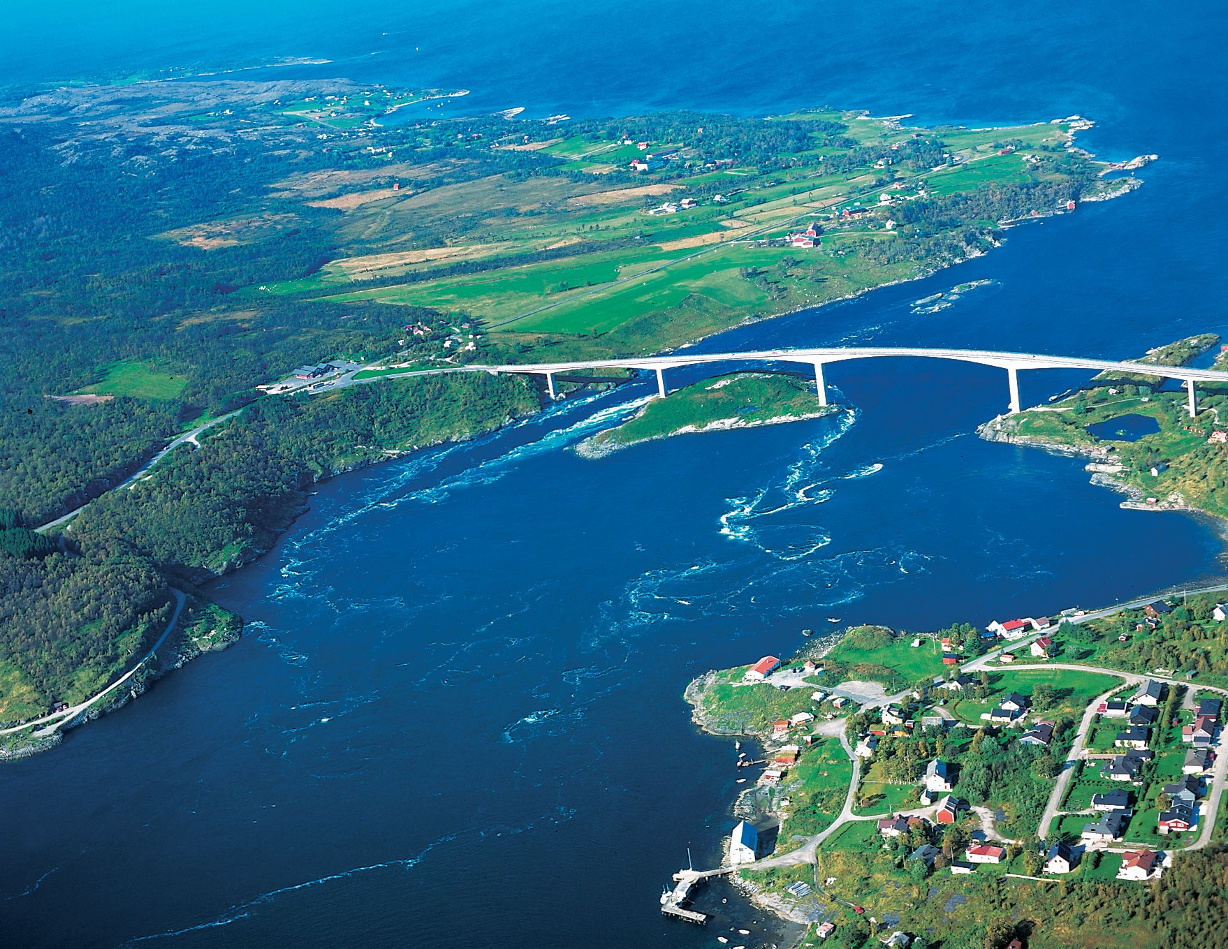
Saltstraumen with in-going (eastward) current in the
main channels between the two larger islands; Knaplundsøya (right) og
Straumøya, to the left.
Photo: Eiliv Leren, Borealis Designstudio, © .
The Moon and the Sun govern the scene
The gravitational forces from the Moon and the Sun generate
a tidal force which pushes the water masses in the world oceans.
This force is not large, less than a millionth part of the
gravitational force at the Earth surface, but it is enough to
generate tides with amplitude of several meters in some
locations on the coasts of the oceans.
The tide enters the Norwegian Sea from the North Atlantic in form
of an extensive wave. The wave propagates northward along the Norwegian
coast with a speed of 450-500 kilometer per hour and its height increases
along the coast northwards. At Bergen the height of mean high water
tide (MHW) is 0.5 meter
over mean sea level (MSL) and at Bodø 1.2 meter
over mean sea level. High water (HW) at
at Bodø is delayed on an average 1 hour and 30 minutes compared to
high water in Bergen. The time from one high water to the next is
about 12 hours and 25 minutes on an average.
Low water (LW) occurs about mid between
to adjacent high waters, i.e about 6 hours after HW. At full and new
Moon the forces of the Sun and the Moon reinforce each other and produce a
higher spring tide. An extra reinforcement occurs when
the Moon is nearest to the Earth (in perigeum) at the time of
full and new Moon. In 2020 this happened at full Moon on 7th of April
and in 2021 with new Moon on 4th of December.
Along the Norwegian west coast the Moon contributes ca. 60-70 percent
to the tidal height while 30-40 percent is due to the Sun.
The regularity of the tidal motion enables reliable predictions of
time and height of high and low water, long time in beforehand, see
tidal tables .
A simple, but practical rule says that it is high water at Bodø
when the full Moon is seen in south direction, high up on the sky, and
again when the Moon is in north low on the sky.
Flow through three channels
The sea level hight in the ocean outside Bodø is driving the current
in and out of Skjerstadfjorden. When it is high water at Bodø
the current flows in and at low water in Bodø the current flows out
through the narrow channels. The surface area of Skjerstadfjorden with
side branches is about 235 square kilometer. With a tidal range of about
1 m large amount of
water masses flow in and out during each tidal cycle, approximated
470 million cubic meter. The main entrance channel between the
island Knaplundsøya
and the Storholme is narrow, about 100 m across and about 30-40 m
deep. The cross section area of the main channel, including the branch
between the Storholme and the island Straumøya, is about 5000
square meter. This implies a mean current in the cross section
of about 6 meter per second.
Saltstraumen can run with speed of 5-8 m/s (10-16 knots), but
in the whirlpools the current speed can be stronger.
The other two channels or inlets to the Skjerstadfjord;
one south of Straumøya and the mainland to the east
(Sundstraumen), and another at Godøya (Godøystraumen),
are narrow and shallow and the amount of water passing through these
inlets is much less than through the main channel. But the current can be
strong especially in Sundstraumen where at spring tide one may
see a breaking bore at the inlet.
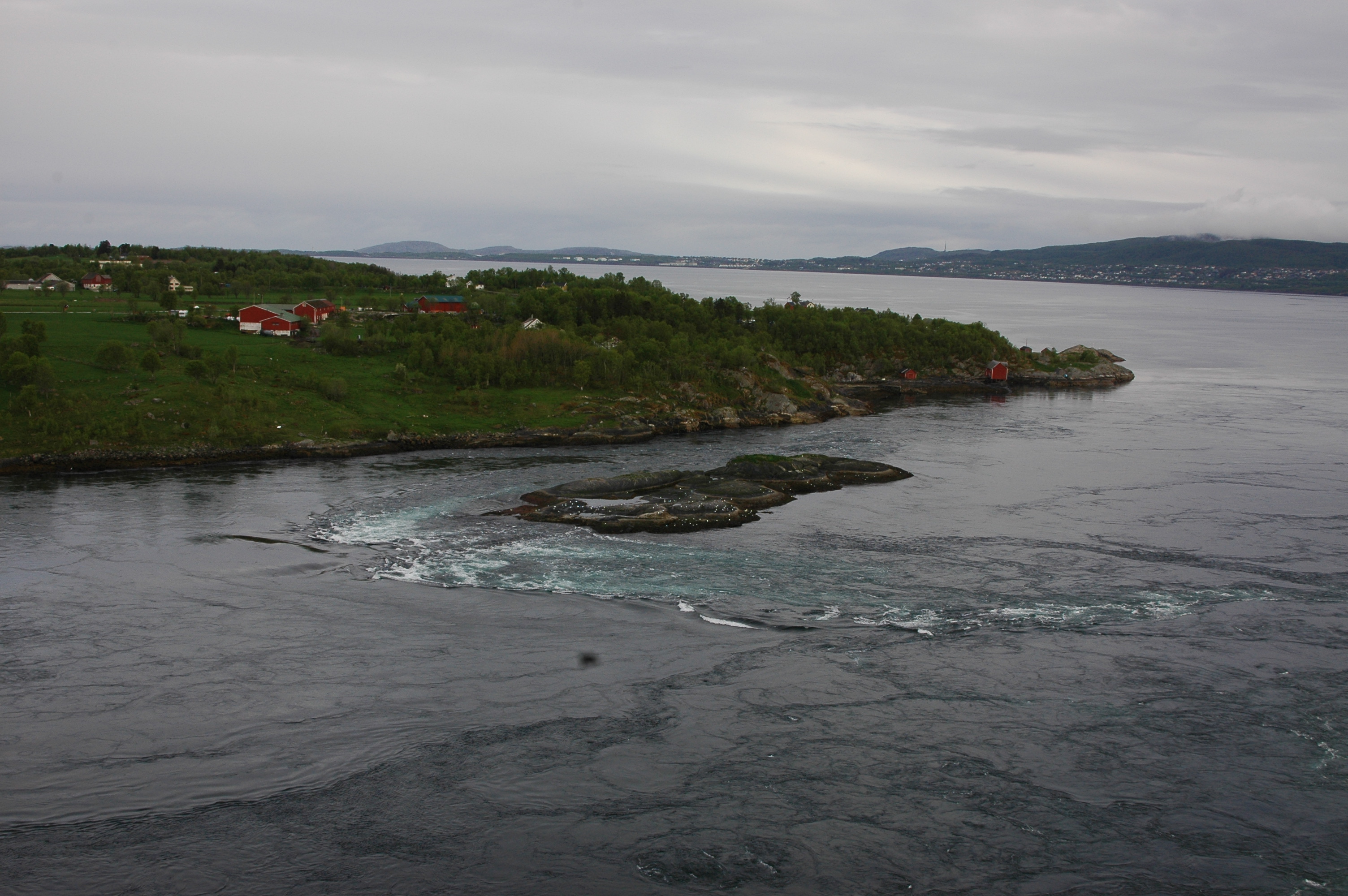
Whirlpools, funnels and updraft
From the low hill tops on both side of Saltstraumen as well as from the
lofty bridge
across the strait, one may have good views of the current,
and hence enjoy watching
the shifting character of the current pattern.
At first sight the current may appear chaotic, but given time
one will observe a well organized and recurrent pattern.
In the shallow zones near land one can see boundary
layers with small scale turbulent eddies. The flow separates
from land at promontories and headlands, per example near the
beacon below the eastern pillar for the bridge on Knaplundsøya,
and likewise on
the opposite side of the strait at the Straumholme, as
see from the current charts
and the pictures (below). In the middel of the channels, outside the boundary
layers,
the current is more rectilinear. Large eddies and whirlpools are seen to
develop on the shear zones separating the interior flow and the
boundary layers. At the center of the spinning whirlpool
funnels ("kjeler") develop
where the fluid is drawn downwards. Surrounding the eddies large
bursts of upwelling fluid ("oppkast") can suddenly appear.
Small light air bubbles
which are drawn into the current by breaking waves and funnels
makes the
spinning eddies and the zones with
upwelling fluid clearly visible.
Generally the current in the main entrance channel flows at its strongest
inwards (east) ca. 1 hour before high water (HW)
at Bodø and strongest outward (west) ca. 1 hour before low water (LW).
The turn of the current direction occurs respectively
about 1 hour after HW and LW
in Bodø. Episodes with storm surges in the ocean outside
Bodø,
or heavy rain or snowmelting in the mountains around Skjerstadfjorden,
will influence the flow through the channel. In such circumctances
the times for maximum current and current
reversals may deviate from the general rule above.
In cases when the direction of the wind and the current are opposite, e.g.
outgoing current and strong wind (and waves) from northwest the sea can
be very rough in the channel with choppy and dangerously breaking waves.
Predictions of current speed and direction in Saltstraumen with the time
for maximum current and current reversals can be found on the
website for
Barentswatch
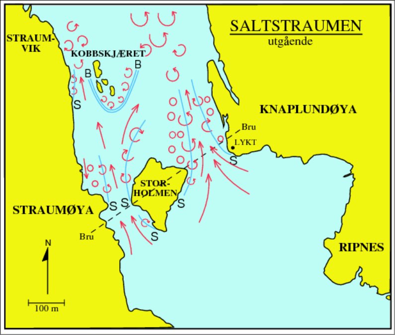
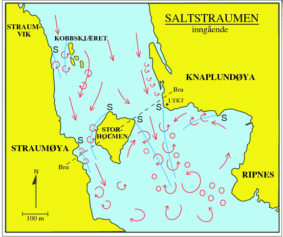
Current charts for in- and out-going current (ebb and flood).
Places where the flow separates from land is marked by the letter S.
Thin blue lines
indicate the current shear zones with eddies (open circles, arrows
indicating direction of rotation). Full circles
mark zones with updraft ("oppkast"). The charts are copied from the book
"Flo og fjære langs kysten av Norge og Svalbard" (2009),
Farleia Forlag. © .
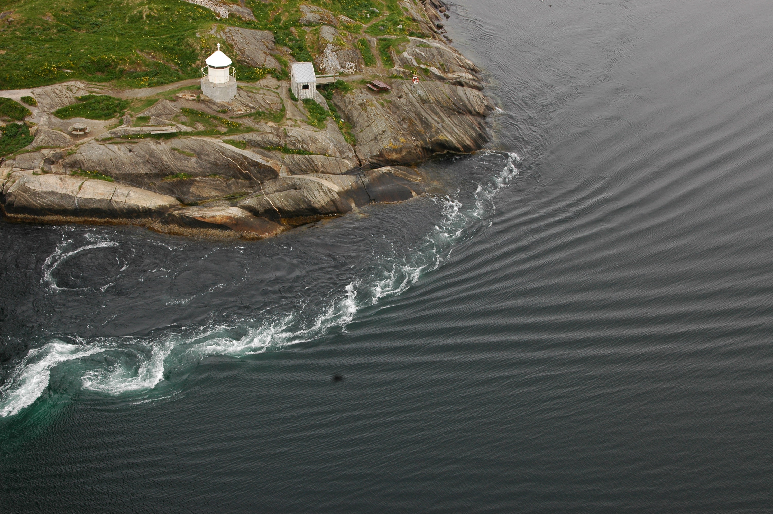
Photos of the out-going (ebb) current. Flow separation (S) occures
at the promontory below the beacon under the bridge at Knaplundsøya.
Turbulent boundary layer are seen near land with eddies and whirlpools along
the shear zone further out. Up-stream of Kobbskjæret (right) a bow wave
zone with strong turbulent flow and multiple breaking standing waves are seen.
Photo: B. Gjevik, © .
A spectacular nearly 12 hour long film show, produced by NRK
(The Norwegian Broadcasting Company),
and first sent live as "slow TV" coverage of Saltstraumen in
May 2016, is available from the NRK archive entitled;
Saltstraumen minute for minute.
Tidal choking
In large fjords with a narrow entrance channel as in Saltraumen
the tidal flow can be choked. The reason is that the large
Skjerstadfjord with side branches is not completely filled
to the same level as in the ocean outside the fjord
in the time span of rising sea level.
Similarly in the 6 hour of ebb the sea level in the
fjord does not quite fall to the sea level in the ocean outside.
The result is that the tidal range; i.e. the difference in height
between HW and LW in the fjord, is reduced compared to tidal range
in the ocean outside. The time for HW and LW in the fjord is also
delayed. At Rognan, innermost in Saltfjorden, the tidal range
is reduced to about 60 percent of the tidal range at Bodø.
Hight water (HW) at Rognan occurs almost 2 hours after HW in Bodø.
The renowned priest of Nordland, Petter Dass (1647-1707),
already described this effect in his celebrated epic book;
"The Trumpet of Nordland"
(Nordlands Trompet). He was probably one of the first to give
a written account of this special tidal phenomena. See the
article in the Yearbook for Helgeland, 2011 (in Norwegian).
.
Good fishing in the current
The strong turbulent flow provides a thorough mixing of the water masses of
the current. Oxygen from the air and nutrients brought up from the deep water
inside and outside the shallow channel are mixed. This provides
nutrition for both bottom flora and floating planktons. Herring and plakton is
also transported in with the current from the ocean outside and supplies
nutrition for larger fish; pollack, cod, haddock and halibut.
From early on the current was known for its rich fisheries and already
Stone Age people were living near by and exploited the resources.
In the Iron Age and Viking Time people living around the current
hunted larger animals; as seals and whales.
To day sport fishermen and tourists are fishing with their rods
from the rocks surrounding the current. Others are fishing from
modern boats with powerful engines which can quickly
be manoeuvered safely in and out between the eddies and whirlpools.
Groups of tourists are taken out on tours with fast
RIBs for even closer contact with the whirlpools.
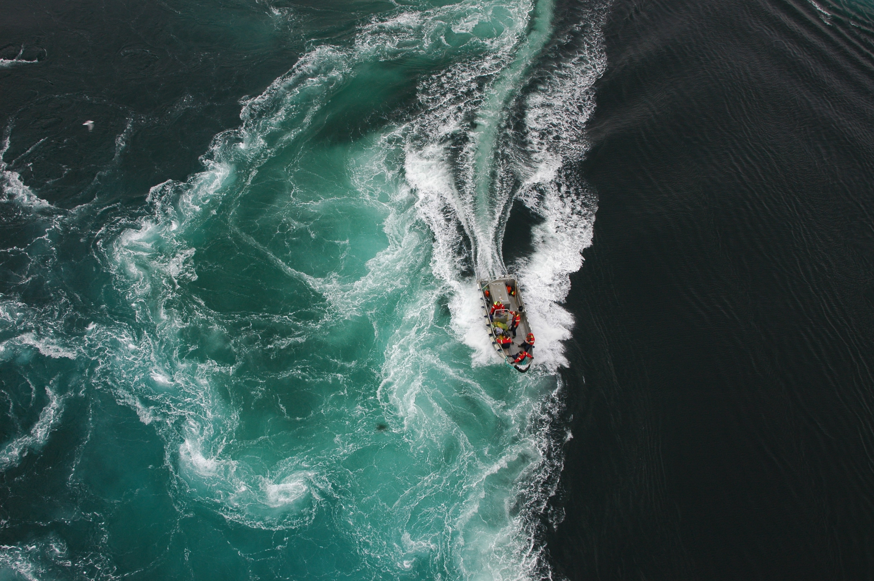
Sport fishermen in a fast modern boat passing
an area with stong updraft ("oppkast")
Photo: B. Gjevik, © .
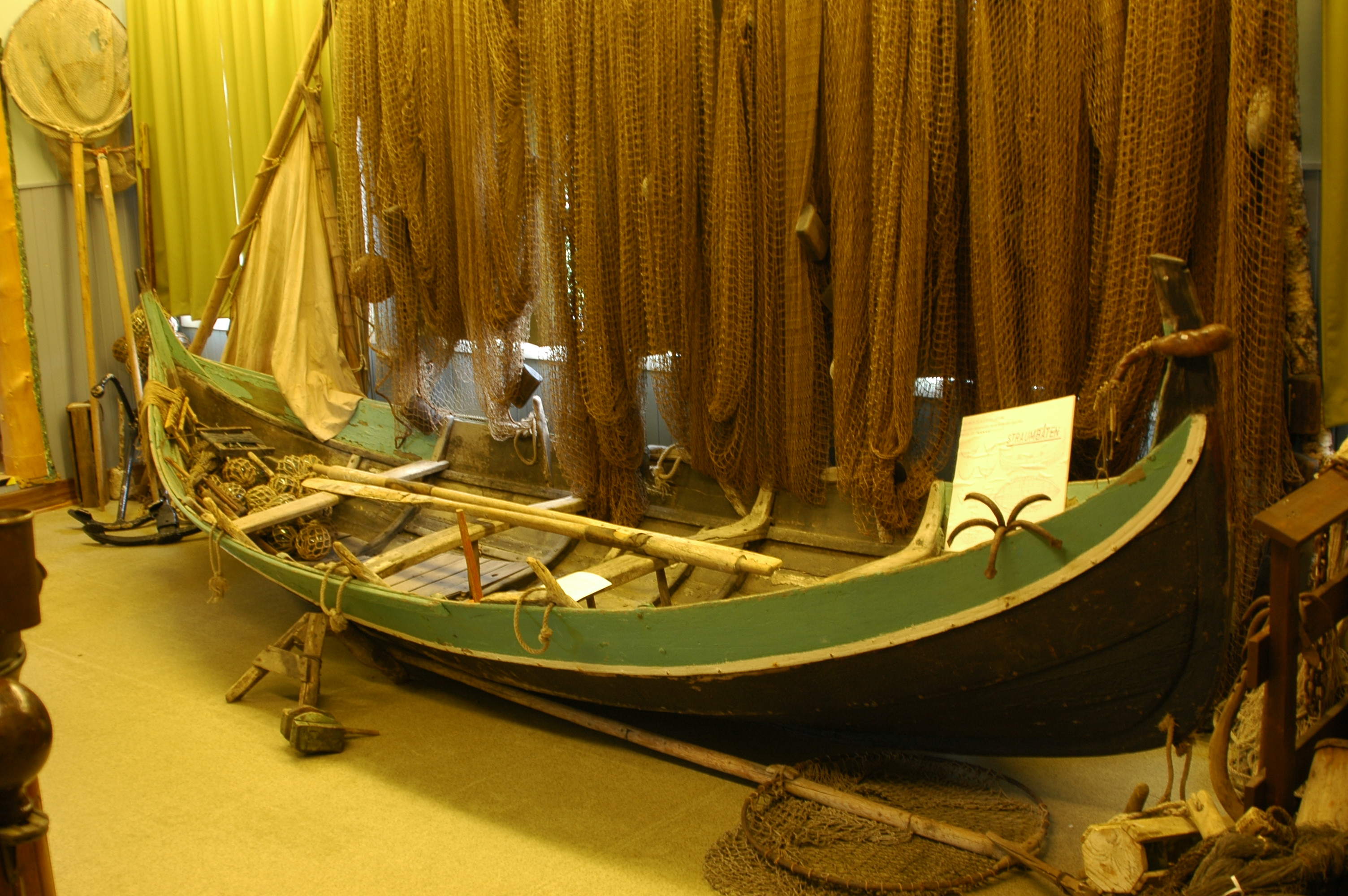
The design of the traditional fishing boat used in
Nordland was modified to make it perform
better and safer among the eddies and whirlpools. The bottom was made
more flat and the keel got a markant swing upward in both
ends. This old "current boat" is displayed at
Saltstraumen Museum.
close by the current.
Photo: B. Gjevik, © .
Accidents and shipwrecks
In older days when small open boats were used (see picture above)
accidents often happened and many perished when their boats capsized
in the whirlpools and the updrafts. It also happened that large
steam freighters was taken out of course by the eddies and run
on rocks and sank. Today most boats have so powerful engines
that serious accidents are more seldom. But the new generation
of sportsmen - swimmers, divers and surfers do in many cases stretch
their safety limits more than good is.
Other strong tidal currents
Many strong and renowned tidal current can be seen
on our planet;
Corryvreckan
between the islands Jura og Scarba on the west coast of Scotland,
the current in the
Naruto Strait
northeast on the island Shioku in Japan,
Old Sow ,
on the border between the states Maine in USA and New Brunswick in Canada, the
Nakwakto
and
Skookumchuck narrows in British Columbia on the west coast
of Canada. Here , northeast of Vancouver Island, there is a maze of lagoons
and channels with extremely strong tidal currents as displayed by
beautiful scenic scenes in a video from the
Roaring Hole Rapids . Very strong tidal currents are also found in
Talbot Bay
in West-Australia and in Canal de Chacao between the island Chiloe and mainland
Chile, only to name a few. The world-wide known
Maelstrom outside the Lofoten Headland should also be mentioned.
The Lofoten Maelstrom was described in fantasy stories from the
eightteens hundred by widely read authors;
Edgar Allen Poe og
Jules Verne .
Some claim, especially people associated with the local tourist industry,
that Saltstraumen is the world strongest tidal current. This is, however,
by no means documented and such comparisons are also difficult to make.
Nevertheless
it is true that Saltstraumen is an unique world class tidal phenomena,
which relatively easily can be accessed and watched without advanced
and expensive equipment.
People have lived around the current and of its resources
for several millenniums and fascinating
stories of their life and struggle are carried down to us by
the sagas.
Raud den ramme (the unyielding) at Godøy
The saga of the infamous viking king
Olav Trygvesson tells us of a wealthy and powerful
chieftain, skilled in magic, who had his farm at the fjord Salten about
thousand years ago. Olav, then the king of Norway, tried to persuade
him to convert to
christianity and be baptized, but Raud refused stubbornly.
When he and his men was beaten badly in a skirmish with
the king's men south on
Helgeland, Raud fled north with his ship for fair wind.
He had always wind from the
right direction whereever he wanted to go - this came from his witchcraft.
Olav and his men followed after, but when they came to Salten
[i.e.Saltstraumen]
a furious storm stood out through the entrance to the fjord and it was
impossible for them to sail in. They waited for several days, but the
wind and the sea spray stood steadfast. Olav then asked
bishop Øystein, who followed the king, if he could break the witchcraft.
The bishop answered that he could try if God would lend them some of
his strength.
Øystein put on his full pontificalia and stood in the bow of the king's
ship with candles, crusifix and holy incense. The bishop
read the gospel, said prayers, and sprinkeled holy water on the ship.
Then they could row in and the others followed in the wake of the king's ship.
They captured Raud home on his farm,
in his sleeping quarter at night. He was again offered
the king's friendship, but answered that he would never follow or
believe in Christ. Raud was furiously mad and mocked and cursed Christ badly.
He was then remorselessly killed on the spot in a gruesome way.
His splendid ship, a drake (dragon)
was taken by the king who gave it the name The Worm. When the sails were
up they looked like wings on the dragon, and this was the finest ship
in Norway - so says the saga.
Literature:
B. Gjevik (2009): "Flo og Fjære langs kysten av Norge og Svalbard".
ISBN 978-82-998031-0-6.
Farleia Forlag
Snorre Sturlasson: The saga of the Norwegian kings (section 78-80), written
about 1200 in old Norse. Translated to modern Norwegian by
Anne Holtsmark and
Didrik Arup Seip. Gyldendal Norsk Forlag, 1964
The article was written in February 2020 by
Bjørn Gjevik,
Farleia Forlag ©.
Translated to English in December 2020 by the author.
A shorter version, with other picture illustrations,
is published (in Norwegian) on the website of
NordNorsk Reiseliv AS