THE LOFOTEN MAELSTROM
Norwegian version of this page.
The Lofoten Maelstrom is located in northern Norway, at 67.7° N,
in the strait between the Lofoten headland and the island Værøy.
It is widely known from the old tales of dreadfull
eddies with large frightning funnels which could draw even
large ships into the abyss.
In the 16- and 17-hundred the mainstream European geographical
litterature conveyed speculative theories and spin based on
these rumors, hardly without any observational facts or critical
assessment.
Some people in Norway, with local knowledge - clerics and administrators, left
more sober and factual written reports.
Recent scientific studies based on modern observational techniques and
computer simulations have provided new and deeper insight into this
spetacular natural phenomena. This short article provides an updated
summary of the historic litterature and results from modern studies.
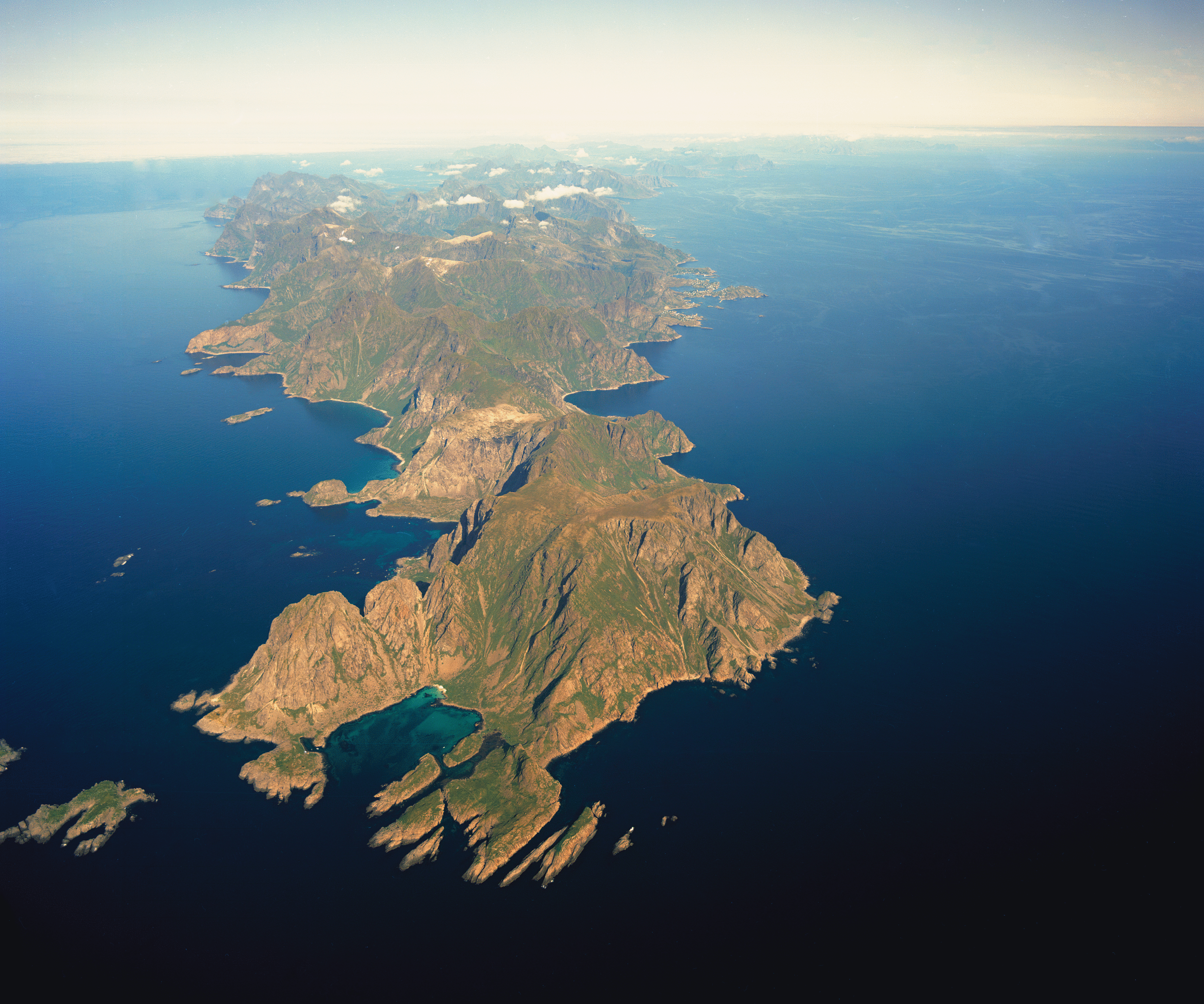
Figure 1: The Lofoten Headland with the small bay - the
harbour for the old fishing village at Hell(e).
The lofty crags of Hellseggen are towering behind - 1800 ft above sea level.
It was here on Hellseggen the old story-teller in Edgar Allan Poe's
worldwide known
story
"A Descent into the Maelström"
stood when he so lively described how his ship was drawn
into the funnel of an enormous powerfull eddy and pulled down into the abyss.
Photo: Fjellanger Widerøe ©
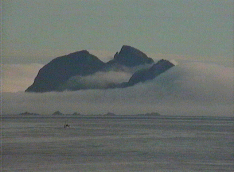
Figure 2: Thick ocean fog spills in over the island
Mosken - mytical mountains ! Behind the small fishing boat to the left,
the low islands Høgholm, Keilholm, and Svarvan can be seen,
all mentioned by Edgar Allan Poe.
Photo: B. Gjevik ©
What is the name ?
The Maelstrom is known by different names.
The Moskenes Current, after the name of the community
Moskenes , has been much used also on maps, but this is
obviously a relatively new name.
From long back in time the current had its name, Moskstraumen, after
a small island Mosken (fig. 2) located in the middle of the current,
ca. 8 km southwest of Lofotodden (The Headland), in the direction of the
larger islands Værøy and Røst further out.
The Norwegian priest, Petter Dass, wrote Mosche-Ström in his famous book
Nordlands Trompet from ca. 1685 and the bishop Erik Pontopidan
used Moske-Strömmen in his description of Norway from 1753.
In an account published by Det Kongelige Norske Videnskabers Skrifter
(1824) the name was written Mosköe-Strömmen.
This shows that the name has it root from the name of the island Mosken.
The most correct name (in Norwegian) is therefore
Moskstrømmen or Moskstraumen. The latter is supported by
the local spoken dialect.
The old stories
Already as early as in the 15-hundred, Moskstraumen was mentioned in
Norwegian documents and reports.
Erik Hansen Schønnebøl (ca. 1535-1595) was an administrator and
tax officer in Lofoten and Vesterålen. He had obviously
been in contact with local people since he very lively could describe
( ca. 1591) how current and waves interacted strongly during extreme wheather
conditions. In translation his account reads:
"... This small village Hille [Helle on Lofotodden] is famous
for the reason, that when this Moske ström is in its
right stature and the wind is opposite of the current, then the current
become very boisterous and produces a load rumble, so that the land and
the ground
shiver [from it], and the houses are shaking [from it], and an iron ring,
on the door of the house, made to open the door with, is shaking
back and forth from the roar of the current and the storm. Many people
believe that there is a swallow in the current or in the ocean outside ..."
The Norwegian priest and historian, Peder Claussøn Friis (1545-1614),
mentioned Moskstraumen in his "Norriges Beskriffuelse"
(Description of Norway)
from 1613. Friis repeated many of the accounts from
Schønnebøl, but he dismissed the notion of an ocean swallow.
Instead he argued that the current follows the flood and ebb which
come at six hour intervals. He reckoned it to be a
phenomena of tidal origin.
Reference 3 and 6 (see list below) include a critical summary
of the old stories of the maelström. An attempt is made to
examine the descriptions on the basis of scientific principles
and theory, that has previously not been done. In most cases
the stories have been copied and reprinted without questioning
their value and relevance or if they mostly have to be regarded as historic
curiosities. Actually, many historians either by conveniency or
ignorance, have avoided to separate pure fantacies from factual observation
when reporting on the subject.
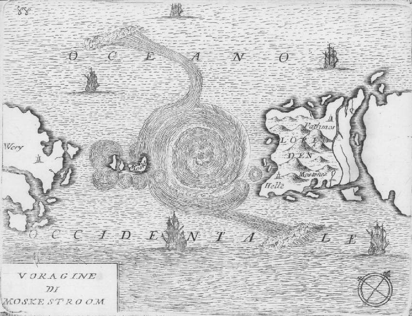
Figure 3: An artistic view of the whirlpool at Lofotodden by the
famous Italian cartographer Vincenzo Coronelli (1650-1718).
Photo from the original graphic print.
Farleia Forlag ©
The famous priest of Nordland, Petter Dass (1647-1707), describes
both Moskstraumen and
Saltstraumen
in epic poetry in his monumental and celebrated book
"Nordlands Trompet" (The trumpet of Nordland). He may have commenced
the writing already in the 1680-decade, but the book was finally
published in 1739 - long after his death.
Sir Petter stated explicitly that the strength of the current
follows the phases of the Moon, with strong current at the time
of new and full Moon. In other words - clearly a tidal current driven by
the forces of the Moon and the Sun.
He reasoned further; A very large volume of water has to flow
through the strait at The Lofoten Headland and the other
passages between the islands further east in Lofoten, when water level
in the large fjord of Vestfjorden changes from high to low water
in 6 hours time (mean tidal ranges ca. 1,8 m ). These thoughts and reflectipns
are much more advanced, and more in line with the thinking
of British scientists at the time (e.g. Newton, Halley), than the contemporary
writers of the prevailing geographic litterature from continental Europe.
The latter writers continued to spin on the speculative concept
of an ocean swallow and subterrain tunnels where the water flows
between the Norwegian Sea and the bay of Bothnia. The large
maelström eddy was thought to form at the entrance of this tunnel.
These lofty speculations provided the backbone for the dramatic
narratives of the American author Edgar Allan Poe (1841)
"A Descent into the Maelström"
and the French, Jules Vernes (1869),
"Vingt mille lieues sous les mer" .
Results of modern research
From the North-Atlantic a large tidal wave is propagating into the
Norwegian Sea. The wave is generated by the gravitational
attraction of the Moon and the Sun (ref. 6). The wave moves
rapidly northward along the coast of Norway with a velocity of
about 450-550 km per hour. An animation video
showing the propagation of the wave can be found
on the front page. The wave introduces periodic changes
in sea level between high and low water with a period
of 12,4 hours. At full and new Moon the amplitude of
the wave increases because the forces from the Moon and Sun
aligne and reinforce each other. The amplitude of the wave is largest
near the coast and decreases further out on the continental
shelf.
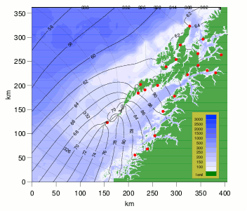
Figure 4: Contour lines for sea level
in cm above mean sea level at mean high water.
Ocean depth in meter with colour scale to the right.
From: Moe, Ommundsen og Gjevik (2002, ref. 4)
Since the width of the continental shelf decreases west of Lofoten
and Vesterålen, the amplitude of the wave increases.
The tidal range, i.e. the difference in height of high and low water,
increases northward along the coast. The mean value is 90 cm in Bergen,
158 cm at Rørvik, and 174 cm at Bodø. Figure 4 displays results of
simulations of the tidal wave (ref. 4). The chain of islands
in Lofoten and the bathymetry of the
continental shelf outside cause the sea level in Vestfjorden
to rise 20-30 cm higher than on the northern side of the
islands and on the shelf outside, at the time of high water.
This sea level difference drives the flow through the strait at
the Lofoten Headland and through the passages between the islands
to the east - Sundstraumen, Nappstraumen and Gimsøystraumen.
Since the difference in sea level is larges at high and low water
the current will be strong around the time of high and low water.
Actually, Moskstraumen is at its strongest outward, (northwest)
1-2 hours after local high water and strongest inward (southeast)
1-2 hours after local low water.
This is markly different from the behaviour of the tidal current in enclosed
fjords where normally the current is weak (slack water) around
the time of high and low tide.
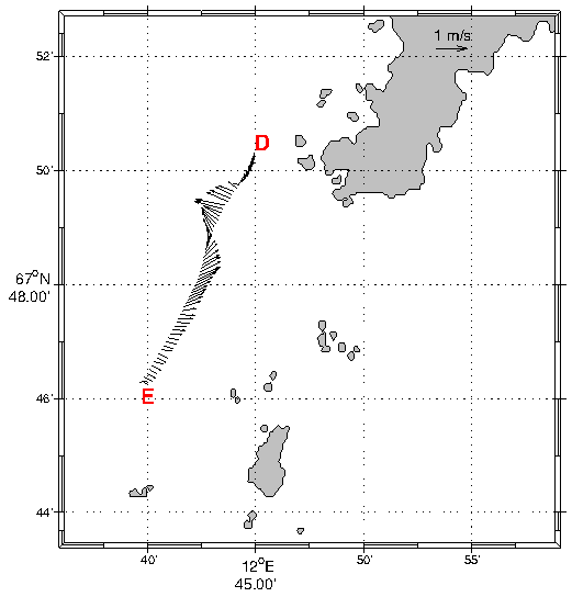
Figure 5: Recorded current strength and direction
by the research vessel "G. O. Sars " on a day in March 2009.
The traverse E-D is marked red in figure 6.
From: Birgit Kjoss Lynge (2011, ref. 8)
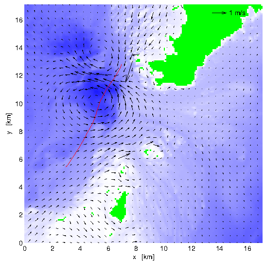
Figure 6: Computer simulated current field for
the time of recorded current (figure 5).
From: Birgit Kjoss Lynge (2011, ref. 8).
Two eddies, each with diameter of 3-6 km, can be seen
west of the the Lofoten Headland. Between the centers
of the eddies a band of relatively strong current appears
with speed 1 m/s (2 knots), and bearing in northwesterly direction.
The current measurements (figure 5) shows a similar
variation in current speed and direction along the
traverse E-D. The situation in figure 5 and 6
corresponds to outgoing current ("utfallsrosta"), 1-2 hours
after local high water.
Eddies of similar strength and extent appear regularly in the current
simulation through the tidal cycle. Their position depends on whether
the current is going outwards or inwards, but they
are always located near or on the shallow ridge between the headland
and the islands Mosken and Værøy.
The simulations confirm that large eddies frequently can develop in
Moskstraumen, but they are larger in extent and not nearly as
strong and intensefied as the eddies featuring in the old narratives.
The persistent strong current through the strait has an important effect
on the exchange of water masses between Vestfjorden and the ocean
on the shelf outside. This was studied by Lynge et al. (2010, ref 7)
who calculated exchange coeffisients for the diffusion
of particles in the flow (pollutant, fish eggs, sea lice etc.).
The earlier model simulations by Ommundsen (2002, ref. 5) show that
although the current changes direction perodically, out and in
through the strait,
it will in combination with a revailing northerly current on the
shelf outside lead to a systematic outward drift of fish eggs and
juvenal fish.
Once the fish eggs and juvenals are on the outside,
they will be carried further northward and into the Barents Sea.
Scientific papers
Below follows a list of scientific papers on The Lofoten
Maelstrom and other strong tidal currents in the area.
The list contains mainly works from
a research group at University of Oslo from the years 1995-2013.
References to the old litterature and works by other researchers
can be found in these papers.
The works are provided with links for downloading. We appreciate it
that references are made if you quote from the articles.
- B. Gjevik, H. Moe and A. Ommundsen (1997) "Sources of the Maelstrom"
Nature, Vol. 388, 28. Aug. 1997, pp. 837-838.
(pdf, 2.0Mb)
- B. Gjevik, H. Moe and A. Ommundsen (1997)
"Strong topographic enhancement of tidal currents:
Tales of the Maelstrom" This is a longer preprint-version
of the article in Nature.
(pdf, 1.0Mb)
- B. Gjevik (1997) "Moskstraumen -- Myter, diktning og virkelighet"
Årbok for Det Norske Videnskaps-Akademi, Oslo
1997, side 157-169.
Artikkelen gir et sammendrag av den historiske litteraturen og de
gamle segnene på norsk.
(pdf, 0.8 Mb)
- H. Moe, A. Ommundsen and B. Gjevik (2002) "A high resolution tidal
model for the area around The Lofoten Islands, northern Norway"
Continental Shelf Research, Vol 22, pp. 485-504.
(pdf, 1.0 Mb)
- A. Ommundsen (2002) "Models of cross shelf transport introduced by
the Lofoten Maelstrom"
Continental Shelf Research, Vol. 22, pp. 93-113.
(pdf, 1.1 Mb)
- B. Gjevik (2009) "Flo og fjære langs kysten av Norge og
Svalbard" Farleia Forlag , Jar
ISBN 978-82-998031-0-6.
- Birgit Kjoss Lynge, Jarle Berntsen and Bjørn Gjevik (2010)
"Numerical studies of dispersion due to tidal flow through
Moskstraumen, northern Norway." Ocean Dynamics, Vol. 60, pp. 907-920
DOI 10.1007/s10236-010-0309-z.
(pdf, 2.1 Mb)
- Birgit Kjoss Lynge (2011) High resolution tidal models for
the Norwegian coast. PhD-dissetation Department of Mathematics,
Univerity of Oslo.
- B. Gjevik (2011) "Vær vind og sjø - fra Petter Dass til moderne
forskning" Årbok for Helgeland 2011, side 10-18. Published by Helgeland
Historielag, editor Harald Monssen. ISBN 978-82-00148-41-1.
(pdf, 0.8Mb)
- Birgit Kjoss Lynge, Karina Hjelmervik, and Bjørn Gjevik (2013)
"Storm surge and tidal interaction in the Tjeldsund channel,
northern Norway" Ocean Dynamics, DOI 10.1007/s10236-013-0625-1.
(pdf, 2.1Mb)
Article written by Bjørn Gjevik, dr. philos, professor emeritus UiO,
Farleia Forlag ©.
Last update: 21 August 2023